Peakbagging trip

Eric Morse and I are trying to visit all of the state high
points, and do some running at each. Prior to this trip I’d visited 44 and Eric
had 35. Our plan was to bag 6 southern states in a very short period of time
(flying out on Thursday morning and back on Saturday). I already had all six of
these states but was looking forward to heading back to them. Travel with Eric
is always fun.
We got in a 3 mile run at 3am before heading to the airport
on Thursday morning. I had a plan to get the miles we wanted, bag the peaks,
and even get a few hours sleep each night. Once we touched down in Charlotte we
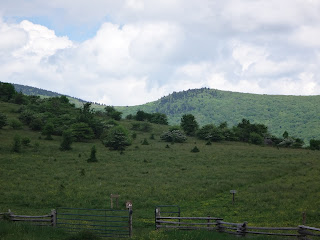
had a 3 hour drive to Sassafras Mountain (3,554’) the highest point in South
Carolina. We arrived at 2pm and hiked the ¼ mile from the parking lot to the
summit. It was hot and humid. The top had been recently clear-cut so there was
a nice view. There was also a high point marker, bench, and the benchmark
showing the top. The parking lot was just 50’ lower than the top. We did a 3
mile run, checking out part of the Foothills trail. When that got steep we hit
the access road, and finished the run with a trip back over the summit. That
got us an extra 800’ of climbing.


After Sassafras we had another 3 hour drive which got us to
Brasstown Bald (4,784) the highest point in Georgia. We ran from the parking
lot up the paved trail to the top. The .6 to the top had just over 400 feet of
climb. We ran pretty easily up in 8:50. Everything was a bit wet from the
thunder storm that we’d missed. We were also too late to get inside the summit
building as it was now after 5pm. After a few pictures we ran back down (6:09)
and then added on some more distance by dropping down the access road and
returning to the parking lot. I got in my 10 miles for the day and was happy
about that. 85 miles and 2 hours later we were done for the day overnighting in
Cherokee NC.


We were up before sunrise on Friday morning and off to
Clingman’s Dome (6,643’) the highest point in Tennessee. We caught sunrise from
the parking lot then ran the .7 to the top on the paved trail which climbed 300’
in 8:42. Again it was time for some pictures then the run back down (6:16). We
added on an out/back on the access road dropping and climbing another 300’ over
2 miles (one either way). This would be the most comfortable run of the day as
temps were in the low 60s.


After Clingman’s we had a nearly 4 hour drive to the
Kentucky/Virginia state line. We didn’t have satellite radio on this trip so it
was a constant battle to find rock or classic rock stations in the land of talk
radio and country music. We arrived at Black Mountain (4,139) at 11am and it
was 80 degrees and humid in the sun. We parked right on the state line and ran
the 1.65 miles up past the radar station to the summit. The climb of 400’ took
us 17:34, and although it wasn’t particularly scenic it was cooler on the shaded
paved road to the radar station. The dirt road to the top brought us to the
remains of the firetower (no cab and no lower stairs) along with a benchmark and
a plaque noting the high point. After a few pictures, rushed a bit due to bugs,
we ran back down (15:24) and were off again.


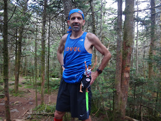
After Black Mountain our goal was Mt Rogers (5,729’) the
Virginia state high point. This was the one I was most looking forward to as it
was the longest run and it would all be on trail (mostly the Appalachian
trail). I’d done this from the south running in on the AT from Grayson
Highlands. It was a nice enough trail run but Eric suggested we start at Elk
Garden (4,460’) and approach the mountain from the East. I was up for something
different and the mileage would be about the same. It was sunny, humid and 70’s
when we took off running up the first open grassy hill. After that most of the
run was on shaded trail. We passed a few hikers but mostly had the place to
ourselves. We made pretty good time covering the 4.35 miles to the top
(climbing a total of 1,300’) in 1:02:34. We took a bunch of pictures on the
wooded summit that had a benchmark and had recently been decorated with a bunch
of flags. The run back was enjoyable and we found ourselves back at the car in
a step over 2 hours (2:00:05) with a descent of 57:24. Eric kicked it in over
the final ¼ mile to break 56 minutes and 2 hours which concluded a 15+ mile
day. We had another drive of over an hour that brought us to Boone NC for our
final night.


We were up at 4am on Saturday with an early deadline (flight
at noon). We arrived at Mt Mitchell (6,678’) before sunrise and before the gate
opened. There were some “No Parking” signs off to the side but it looked okay
to park on the side of the dirt road. We weren’t going to be there long anyway
and figured we’d be safe. We had a very enjoyable easy run up the road 2.5 from
the gate to the top climbing 600’ in 24:39. After a few pictures we ran back
down in 21:31 and then headed back up part way in order to get in the 8 miles I
wanted. Just like that our trip was over…well we still had 2.5 hours of driving
to the airport.


In all we ran 32 miles over 6 state high points with 8,000’
of climb/descent. If nothing else it was good mental training in preparation
for the Mt Washington road race!
No comments:
Post a Comment