Deasey Mountain (aka Daicey Mountain): This is
one of the very few fire lookouts in Maine, as opposed to fire TOWERS. The long
approach (7 miles each way to the start of the climb) and relatively low height
of this peak (1964’) make it a rare treat. I love long approaches, especially
when they are on run-able logging roads. I misread the trip reports on this and
had it in my head that it was 6 miles each way but that was “as the crow flies”
and didn’t include the climb. D’oh! This would be my longest run since the 20
mile rail trail excursion back in March.


Kevin and I drove from Millinocket (Wilderness Edge
Campground – hot showers, a swimming pool, and WIFI!) just after sunrise. We
followed the excellent driving directions from “Nate” off of the “Views from the
Top” website. I’ve posted them below along with mileage (which was not
originally included). We spotted 2 moose as we drove through Stacyville. After
crossing over the East Branch of the Penobscot (near Whetmore Falls) we parked
at the four-way logging road junction (12.5 miles from the exit off the highway
all on decent roads) and prepared for the run.

It was a bit buggy (deerflies) on the logging road but not
terrible. Conditions were good with clear skies and temps in the upper 60’s at
7am. Not even ½ mile into our run and we came across a moose! We walked by as
he stared at us from about 50 meters away, once out of his sight we started back
running.

At almost exactly a mile we had a stream crossing. We could have
driven to this point but certainly no further. Someone had rigged up a small
bridge and we easily crossed.

At 3 miles we crossed the Wassataquoik stream on
a large wooden bridge. It was springy and had a few holes but was mostly in
okay shape (at least for a couple of runners).

The next half-mile had me a bit
nervous as we went East instead of North. There had been a couple of minor
turns that looked promising but this was definitely the “main road” so we stuck
with it as it bent back North. At 4.5 miles we reached the beaver dam that
blocked the trail. It was a minor bushwhack and a careful crossing of the dam
and we were off again.

Three-Quarters of a mile later we crossed a minor stream
and I forgot to restart my watch losing .3. We were starting to consider what
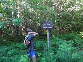
we’d do if we were on the wrong trail when we finally arrived at the sign for
the trail to the summit (at 6.7 on my watch or almost exactly 7 miles from our
car).

Of course I forgot to start my watch again when we checked
our map and started the climb. In all I’d lose .8 over the course of this 18
mile run, Kevin kept his watch running even when we stopped so we kept comparing
distances along the way. Anyway, we hit the turn at 7 miles and at 379’ a mere
7’ higher than our starting point! We had 1600’ to climb in 2 miles, definitely
more of a mountain run. For the most part the trail was pretty easy to follow
although not that well maintained. Almost exactly a mile later and we arrived
at the wardens cabin which is falling apart. We stopped and had a short venture
inside to check it out.


There was some signage for the International
Appalachian trail, but we weren’t sure that was a feasible route for us for the
way down. There was also signage to the summit and the trail at this point
became well worn (you could easily miss the way we came up at as it was pretty
overgrown). Finally we reached our goal after 9 miles and 1:55 after we’d
started.

Unexpectedly we bumped into a couple who were hiking the IAT
and had reached the top of Deasey about ½ hour before us. We chatted with them
for a bit, took some pictures (incredible view of Katahdin), and had a bite to
eat. After about 20 minutes it was time to head back.


The miles rolled by
pretty easily, at least until about 14, then it was just a matter of “finishing
it up”. We got back to the car just after 11 am with a total time of 4:09 for
the 18 mile trek. Our time running was 1:50 for the run back, so only a few
minutes faster than the way out which is typical for me (and especially on a
mostly flat run like this). Total climb/descent was 1,900’.
This was a good tune-up for our Katahdin ascent planned for
the next day!
From “Nate” on Views from the top (my edits in red): From
Stacyville: Depart I-95 at exit 264 and get on Route 11 South (reset odometer to zero). Follow this into downtown
Stacyville (such as it is), and where 11 mades a sharp left (5.5 miles), to head south to Medway, continue straight
ahead where the road promptly turns to dirt. Please use caution when driving on
this road, especially if you have a lower car. At 10.5
miles the main road goes left and starts dropping towards the river. Arrive at
the River at 12.5 miles.


No comments:
Post a Comment